In the current climate where there is a premium on quick, affordable, dependable solutions Steer Davies Gleave’s TravelStyle tool has really come into own as a way to very quickly obtain a good idea of the underlying demand potential for use of a particular transport mode. We can use TravelStyle to evaluate options and obtain a reliable indicator of whether or not a scheme is worth pursuing, quickly and at a comparatively low cost.
TravelStyle (there is actually a different, tailored version for each market) is based on geodemographic principles and exploits the strong link between people and the transport they use. We have explored this link over many years (our first TravelStyle tool was developed for the rail industry in 1997) using datasets such as:
- LATS and LTDS (LTDS – London Travel Demand Survey and its predecessor LATS - London Area Transportation Survey)
- Customer satisfaction surveys
- Customer databases
- Numerous local travel surveys
The travel behaviour information from these has been fused with geodemographic data in the form of the MOSAIC classification system.
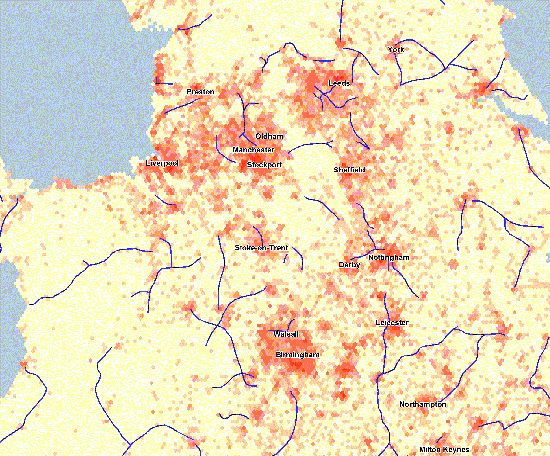
Illustration: demand for rail travel
To illustrate the concept we have considered the demand for rail travel across the country. Based purely on the type of people living in an area and the extent to which they are the kind of people who travel by rail, we have calculated the relative demand for rail for every 1km hexcell in the UK. This data has then been mapped so that the more demand the hotter the colour.
This is a tool which Beeching didn’t have when he reviewed Britain’s railways , but if he had of been able to use it he may have come up with a somewhat different result!
The Reshaping of British Railways, published in 1963 and which was accepted by the government, proposed that a third of Britain’s rail lines should be closed in order to stem the massive losses the railways incurred. In the event, the programme was not fully implemented, in part because the closures failed to achieve the expected cost savings, and also due to a belated acceptance of the social role of railways, and the negative consequences of increased reliance on the car. Nevertheless, between 1963 and 1970 nearly 4,000 miles of railway were closed.
In Figure 1 below the underlying potential for rail travel is mapped along with the rail lines Beeching identified for closure and it can be seen that while there is a clear logic for some of the lines, there is much less for many others.
While this illustration is based on rail travel, the same principle can be applied to other modes and we have done so for bus services, tram services, airports, cycle lanes, and even inland waterways.
Figure 1: Underlying demand for rail and rail lines cut by Beeching This map shows the lines which Beeching proposed should be cut, superimposed on a map of the underlying demand for rail travel where the red highlights high demand. The demand is based on the number and profile of people living across the area and utilises our TravelStyle geodemographic system which itself is based on MOSAIC and data on travel behaviour.